Analysis of Hyperspectral Images
EnMAP and PRISMA hyperspectral images were analyzed for the area of Zagreb County and part of Istria (Vrsar hinterland) with the aim of evaluating usability of hyperspectral images (spatial resolution 30 x 30 m) for detecting smaller areas (e.g. 100 m2).
The following characteristics were identified for EnMAP and PRISMA sensors:
- the number of spectral channels,
- the spectral range of sensors,
- spectral resolutions and
- spatial resolutions.
After defining the objects of interest, spectral responses were analyzed (the amount of energy an object reflects, absorbs, scatters or emits at a specific wavelength of light), spectral signatures were defined (graphs of the spectral response of a specific object across the electromagnetic spectrum, enabling object recognition), and a spectral library was created (a collection of spectral signatures of different objects of interest) to extract objects of interest.
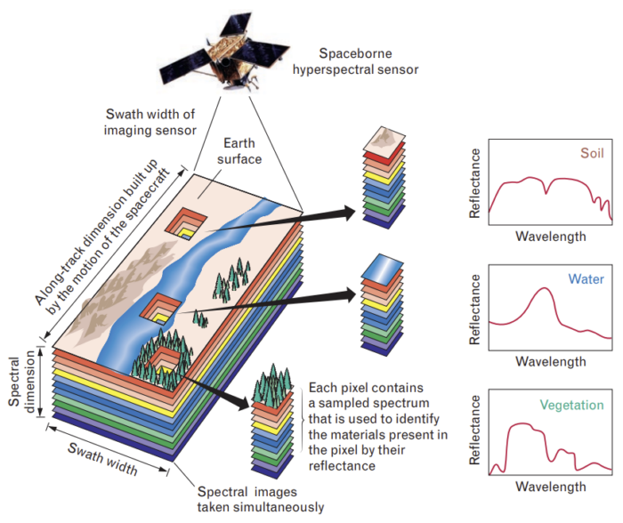
Principles of Hyperspectral Sensors (Lincoln Laboratory Journal)
Field Data Collection and Processing Using a Handheld Spectroradiometer
A handheld spectroradiometer is a portable instrument that measures light intensity across different parts of the spectrum, collecting spectral samples. On September 11, 2024, in situ spectral imaging of agricultural cover on a plot in the Žitnjak area was conducted using a spectroradiometer. During imaging, the sampling point locations were recorded, including:
- X coordinate,
- Y coordinate and
- ID of the recording point with vegetation composition descriptions.
The results were compared with spectral response analysis from EnMAP satellite hyperspectral images, where the spectral reflectance of the observed plant species averaged about 30% in the infrared spectrum. In the visible spectrum, the spectral reflectance was higher between 500 and 650 nm compared to other vegetation.
Project conclusion
Conducted analysis of field data confirmed the results of the analysis of proximal spectral imaging of agricultural cover using a spectroradiometer in the area of the city of Zagreb. Observed plant species exhibits lower reflectance in the infrared spectrum, which is important for distinguishing plant species based on the specific cellular structure of the leaf.
EnMAP hyperspectral images and EnMAP-Box tools offer numerous analysis options, but high-quality analysis require larger objects (minimum 90 x 90 m, i.e. occupying an area of about 8,000 m2). Analyses of PRISMA images were limited due to the currently insufficient processing tools, which primarily focus on viewing channels and plotting spectral profiles of individual pixel vectors.
The project provided professional and practical knowledge about satellite missions EnMAP and PRISMA, hyperspectral images and their processing capabilities. We had the opportunity to expand our expertise, which we will implement in the future continuous development of innovative solutions based on Earth observation.